
And much more...
We provide vast range of solutions to utility companies, to major sporting events, to environmental management, to retail stores analysis
Motor Racing
Insight GIS has worked with the White Hot Motor Sport Team to develop an automated real-time navigational and time recording application. The application is one of a few in the rally car racing world.
The White Hot Motor Sport Team competes in Tarmac Rallys (Targa Tasmania, Mt Buller Sprint, Australian Targa Championships). These international tarmac rallys attract the best touring, sports and GT cars in the world. John believes that he has gained a distinct advantage over other his competitors.
Yacht Racing
Insight GIS has completed a number of mapping projects for use in the media , ensuring that maps produced for this purpose are clear, simple and informative. This map was created for the Sydney to Hobart Yacht Race. It clearly shows where the yachts were located in relation to one another and the race record. Our Sydney to Hobart maps have been used nationally by television programs and newspapers throughout Yacht Race coverage.
Store Locations
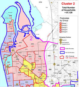
We produce maps that enable you to visualise where your markets are in relation to store locations, other services, competitors and a range of other factors. This helps you identify where to open new stores, where to hold marketing campaigns, where to generate sales, and where to locate distribution networks.
This map shows the location of a target market based on postcode segmentation, as well as the number of households within that postcode and shopping centres in the region. It was produced to help a company decide upon the best location for new stores in order to reach its target market most effectively.
Rock Concerts
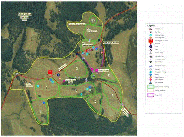
You can get maps produced for almost any purpose so let us know what you need to see on a map and we will create it for you.
This map was created for the Falls Festival organisers to help manage the site during the festival. It shows the location of amenities, camping sites, stages, food, roads, beach access and more. The map enabled organisers and festival goers to easily see where to go and what to do at the event.
Our mission
At Insight GIS we are focused on you, the customer. To maximise the benefits to you we must thoroughly understand your needs and fears. A healthy and effective business relationship can then be built, with a very high probability of success. After 20 years this approach has organically become our core value.
Contact Us
2 Gregory Street
Sandy Bay, Tas 7005
+ 61 3 6234 5833
+ 61 3 6234 5899
info@insightgis.com.au
Sitemap
Home / Services / Solutions / About / Contact Us
![]()